The European Satellite Navigation Competition was established in 2004, and has rewarded the best services, products, and business cases that use satellite navigation in everyday life.
AutoAlert uses satellites to provide location information to our customers so they can better manage their vehicles and better manage their jobs.
Following is our response to the award
AutoAlert mission is to eradicate paper based job sheets for remote workers.
Using paper based job sheets is labour intensive with lots of duplication, especially as more subcontractors get involved in the job. In addition, no one knows what is happening with each job until the job sheet is returned. This leads to stress, anxiety and lots of chasing. It often also leads to delayed or inaccurate invoices as job sheets are returned with difficult to read or missing information.
AutoAlert has a massive opportunity to create a social network for blue-collar workers which eradicates the need for paper based job sheets whilst improving the performance and efficiency of companies operating in complex supply chains.
We are a small company, however we have already achieved big things with almost 20,000 customers on our platform.
With AutoAlert jobs we believe we can acquire many more customers due to the vitality of our platform and huge value in our customers connecting to their own customers and subcontractors and then being able to share the status of their jobs and communicate easily via a desktop, tablet or mobile telephone.
Our mission aim is to eradicate paper based job sheets.
Millions of job sheets are created each day for remote workers. They give information about what jobs need to be done and are used to get information back about what work was done for each job.
Unfortunately, this is a very labour intensive process with lots of duplication, especially as more subcontractors get involved in the process. In addition, no one knows what is happening with the job until the job sheet is returned. This leads to stress, anxiety and lots of chasing. Invoices may also be disputed or delayed when information is missing, difficult to read or inaccurate.
AutoAlert jobs resolves these problems by creating a “social network for blue-collar workers” which allows companies to connect to each other, share jobs and then update those jobs on a mobile telephone while the job is being done rather than at the end of the day or week.
Prior art in this field is provided by companies such as Oracle and SAP who offer complex Enterprise resource planning (ERP) systems to large organisations. More recently, companies such as GeoOp and vWorkApp have entered the market with more simple work tracking solutions using smart phones.
These solutions work well for individual companies but fall down when more than one company is involved in the job as existing applications do not allow companies to connect to each other and share the status of their jobs. AutoAlert is a connected system and works right the way along the supply chain. This means that you can see the status of your jobs which are being completed not just by your own engineers but also the jobs which are being done by your subcontractors.
The key components to the system is AutoAlert’s cloud based infrastructure combined with mobile phones and/or GPS tracking devices. Utilising the location of the mobile phone or GPS tracking device enables the key aspects of the job to be updated automatically such as when an engineer is on site. it also helps with health and safety concerns especially when engineers are working on their own and in potential dangerous conditions.
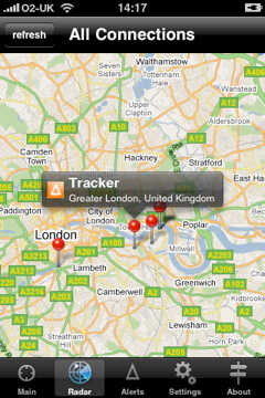
AutoAlert uses GPS, CellId and WiFi Location to check the location of the engineers, create location-based alerts and update the status of the job when an engineer arrives or leaves the job site.
We prefer CellId to derive location as it is the most readily available source of location and is available at the lowest cost in terms of power. It also provides adequate accuracy for our needs.
GPS and WiFi are also used to improve on the accuracy of the location. GPS is pretty ubiquitous and is available in most smartphones and a wide choice of tracking devices. GPS chips are cheap, readily available and well-tested.
We are keen to use other location technologies including Galileo as this will likely improve accuracy and reliability. However, we are mostly reliant on their adoption by mobile telephone handset manufacturers.
Our target market is growing companies with remote workers. This could include electricians, plumbers, transport and logistics companies and fire and security companies.
There are two target markets for AutoAlert Jobs. The first is small but ambitious companies. Bigger than one man bands but without the resources including time and money to invest in more complex systems.
In the UK there are almost 35,000 electrician companies with a size of between 10 and 100 employees. There is a similar number of plumbing companies. There are almost 60,000 transport and logistics companies.
They can benefit by being able to take on more work, offering a more professional service to their customers and by being able to check the status of their jobs.
Competitors to AutoAlert include GeoOp and vWorkApp who offer job scheduling software on smartphones. However, their applications only work internally which means that companies within this market cannot connect to their own customers and subcontractors and share the status of their jobs with their customers and subcontractors without logging in and out of different systems or different accounts, duplication and extra work.
At the other end of the spectrum is large national and global companies who have a number of sites and use many subcontractors. Facilities managers at these companies are a particular target as they have a number of small jobs which are sent to their own staff or to subcontractors. They can benefit by being able to check the status of their own jobs and being able to check the status and performance of jobs done by subcontractors.
Competitors include ERP systems from the likes of Oracle and SAP. However, again these are focused on individual companies alone, they are also expensive and complex which means these companies cannot force their smaller subcontractors to use the system to provide the status of their jobs.
Using paper based job sheets is expensive in terms of administration, duplication, chasing of employees and subcontractors and disputes over invoices. Our customers estimate the cost for each job done using a paper based job sheet is £40 per job. This is about 10% of the value of a typically job.
By using AutoAlert, we can eradicate the majority of this cost as there is no more duplication, information is readily available to all interested parties, therefore less chasing of employees and as invoices can be raised automatically and as soon as the job is completed, this means less disputes and quicker payment of invoices.
AutoAlert is available on a subscription basis with three pricing plans.
Bespoke solutions are available for large companies depending on their specific requirements.
Large companies spend a lot of time and money taking on subcontractors. However, once a contract has been signed, it is very difficult to check the performance of these subcontractors as they have no visibility over the job until it is completed or an invoice is received.
Even if the company has their own job scheduling system, they can watch jobs done by their own employees but cannot check those jobs done by subcontractors.
AutoAlert has over 18,000 customers using its GPS tracking platform. However, growth is escalating as our customers see the value in connecting to their own customers and suppliers and sharing the status of their jobs.
As more customers start using the jobs functionality of AutoAlert then the potential for growth in customer numbers is huge
Find out more about AutoAlert GPS Tracking and AutoAlert Jobs and how they can benefit your business.
2G | 2.5G | 3G | 802.11 | ADC | ADSL | A-GPS | API | ASP | AVL | Bluetooth | CANBus | CDMA | D-GPS | DECT | EDGE | EDI | E-OTD | ERP | ETSI | FMS-Standard | GIS | GPS | GPRS | GSM | HTML | IP | IrDA | ISDN | ISP | JAVA | LAN | LBS | MOBITEX | OBDC | PDA | PMR | PVN | RDS-TMC | RF | RFID | RMS | SIM | SMS | TETRA | TDMA | TMC | UMTS | WAN | Wi-Fi | WLAN | WMS | VoIP | VPN | XML | WAP | WVPN | WWAN
Second generation mobile telephone network, also known as GSM
Also known as GPRS. Mobile communication system for transfering data. Most likely used by Telematics applications such as AutoAlerts real time vehicle tracking system. Faster than 2G but lower priority traffic for the mobile networks and patchy coverage.
Third generation European mobile telephone communication standard. Also known as UMTS.
Data transfer standard for wireless local area networks. 802.11a works at up to 2Mbps, 802.11b works at up to 11Mbps whilst the latest 802.11g standard works at upto 54Mbps.
Automatic data capture.
Asymmetric Digital Subscriber line is a way to transmit data over standard telephone lines at speeds approaching cable.
Assisted GPS.
Application programming interface is often offered by companies to allow third party developers to create programmers which link into other systems.
Application Service Provider.
Automatic Vehicle Location is provided by companies such as AutoAlert to help people monitor, protect and better manage their vehicles.
A short-range wireless radio technology that aenables wireless devices such as mobile telephones and accessories to connect to each other.
A wiring network within most new vehicles which connects all the electronic devices within the vehicle.
A digital communications technology (code division multiple access) for mobile telephones.
Differential GPS which is augmented by ground based signals.
Digital Enhanced Cordlesss Telecommunications is a way of transmitting voice traffic for domestic phones and some business phones.
EDGE is an enhanced way of transmitting data over GSM networks at up to 384Knpt.
Electronic Data Interchange.
Enhanced observed time difference is a way of synchronising signals for GSM positioning.
Enterprise Resource Planning System.
The European Telecommunications Standards Institute is responsible for agreeing standards.
FMS-Standard is a system drawn up by Truck manufacturers to provide standards governing data formats for capturing and exchanging information on vehicle systems and particularly for passing it over on-board CANbus networks.
Geographic Information Systems.
The Global Positioning System is a network of 24 satellites based on the US governments network. By using the signals transmitted by these satellites, the position on the earth can be calculated by systems such as AutoAlert.
General Packet Radio Service or 2.5G allows for faster data transmission over the GSM network. Data transfer speeds range from 56Kbps to 115Kbps. AutoAlert uses GPRS to transmit real time information about vehicle movements.
Global System for Mobile Communications is the technology behind the 2.0G network. GSM can be implemented in 900MHz, 1800MHz or 1900MHz.
Hypertext Mark Up Language is used for programming web pages.
Ingress protection is a rating system developed by the International Electrotechnical Commission to describe the ability of electronic products to withstand gas, dust, water and overall dirt penetration. The higher the number the better the protection.
IP also standards for Internet Protocol.
Infrared Data Association is a protocol for sending infra red data between two devices.
Integrated Subscriber Digital Network allows data transfer rates of 2x64Kbps It has now been widely superseded by ADSL.
Internet Service Provider.
JAVA is an object orientated programming language developed by Sun Microsystems. It is ideal for network applications and applets as it is operating system independent.
Local Area Network.
Location Based Services include such services as AutoAlert’s vehicle tracking systems, Multimap’s mapping systems and location based advertising.
Mobitex is an open wireless networking standard used especially for data transmission. It can operate at 80MHz, 400, 800 and 900 MHz (usually 400MHz in Europe). There are over 30 networks operating in over 22 countries with Transcomm being the UK system. The copyright is held by Ericsson.
Open Database Compliance is a way for programs to connect to Databases.
Personal Digital Assistant are basically a scaled down computer which allows for computing on the move. PDA’s with internet access allows fleet managers to see the location of their vehicles whilst out in the field themselves.
Private Mobile Radio is a licence free short range radio technology operating between 446.0-446.1 MHz.
Private Virtual Networks are used by Businesses to create a secure private network over the public internet.
Radio Data System – Traffic Message Channel is used to convey real time traffic information and radio station information to FM radios.
Radio Frequency.
Radio Frequency Identification is a very cheap and short range communication system which allows such things as the tracking of palettes and the identification of drivers using a small card.
Remote access server.
A Sim is the small chip which goes inside most mobile phones and tracking units and contains information about the subscriber. SIM stands for Subscriber Identification Module.
The Short Message Service is a system used to transmit short text messages up to 160 characters long on GSM networks. It was originally used by mobile phone technicians using spare capacity but has grown in popularity wtih billions of messages sent per week. AutoAlert uses SMS to send proactive alerts to customers and to send messages to and from units as a back up to GPRS.
Terrestrial Trunked Radio is a land based mobile radio communication standard.
Time Division Multiple Access is a way to send digital data over systems such as GSM at high frequency.
Traffic Message Channel.
The Universal Mobile Telecommunications System is the European third generation cellular mobile standard also known as 3G. UMTS is the overall system whilst W-CDMA is the technology behind it.
Wide Area Network.
Wi-Fi stands for Wireless Fidelity and is a brand name adopted by the Wi-Fi Alliance which currently has over 200 members. The Wi-Fi alliance promotes 802.11 local area network specification and asserts compliance with it.
Wireless local area network.
Warehouse management system.
Voice Over Internet Protocol is a way to transmit voice data over the internet.
A virtual private network is often used by companies to set up a private network over a public system such as the Internet.
Extensible Mark Up Language is a flexible programming language which is used by companies such as AutoAlert to exchange data with other systems such as Google.
Wireless Application Protocol first allowed the internet to be viewed on mobile telephones. AutoAlert uses WAP to provide vehicle location information to basic mobile telephone.
Wireless Virtual Private Network. As VPN, just wireless.
A digital communications technology (code division multiple access) for mobile telephones.
Wider Wireless Area Network.
Thanks to the Telematics and Mobile Data Guide 2008 for some of the information on which this guide is based.
![]()
Whether it’s the latest GPS system, or most advanced in car entertainment, we at Auto Alert are unreservedly car tech geeks. So it’s edifying when we come across a story that looks likely to make a real difference to the lives of road users.
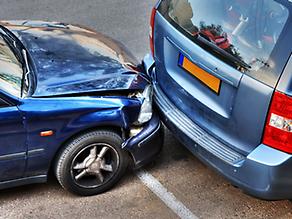
Volvo has often been selected as the family favourite when it comes to high technology and in-car safety. However, news just in from Volvo is that they are also concerned about safety on the other side of the bonnet, on the outside of the car. This means making pedestrian safety more important.
With this in mind this Swedish car manufacturer has developed an external airbag so that any pedestrian or cyclist who may be hit by the vehicle in an accident, will have the impact cushioned.
Of course, it will only be a matter of time before the technology is taken up by other manufacturers. Hardly surprising when Volvo reckon the air bag could save lives in 85% of accidents which would otherwise cause fatality.
Volvo fit a series of sensors to the front bumper and these can detect how hard an object is in a crash situation. If the sensor records the object is soft like a human limb and the car is travelling between 12 and 31 mph, the air bag inflates and will burst through the bonnet of the car, covering the windscreen. This would then help prevent a pedestrian’s head from hitting the windscreen and metal surround. In addition the bonnet would be lifted up by 4inches which would create a cushion above the engine.
They have also developed a pedestrian detector system that can recognise when a person is in the road immediately ahead or about to step into the path of the car. In this case an alarm sounds, the driver is alerted and brakes automatically applied if a crash is unavoidable.
As Thomas Broberg, Volvo’s senior safety advisor commented: ‘We believe this can substantially reduce the number of serious injuries sustained by pedestrians.
If the speed of the vehicle is reduced by the automatic braking from 40mph to 30 mph, allowing the airbag to inflate from under the bonnet, it’s easy to see the possible effect. The two devices used together could significantly reduce pedestrian casualty rates.
Duncan Vernon of the Royal Society for the Prevention of Accidents stated: ‘the introduction of vehicle technology, such as seat belts and airbags, which reduce the severity of injuries to car occupants is one of the success stories of road safety.
‘However, there is potential to improve vehicle design to improve protection for vulnerable road users who are struck by vehicles, and we welcome technology which does this.’
When one thinks how ubiquitous GPS is, the deployment of even more advanced technology and the difference it could make to the safety of motorists is considerable.

After the remarkably un-bureaucratic government proposal to increase the speed limit on motorways to 80mph, a new report has been published decrying the move. The report’s authors claim that a speed increase would be bad for the country on many levels, most importantly by increasing road fatalities and harming the environment.
Public health experts writing in an online report for the British Medical Journal say they are amazed the government would even consider such a proposal given that there is clear research showing an “exponential” link between increasing the speed limit and the number of road fatalities. The journal cites evidence that when similar increases were introduced in the US in 1995, fatalities in road accidents increased by 16.6%. Moreover, the report argued that as heavy goods vehicles would still be capped at 60mph, there was little weight to the argument that a speed increase would help improve economic output by helping to ‘get Britain moving’. However, inevitably, if the speed limit is set to 80mph, more people will feel they can get away with driving even faster and reckless drivers will be more likely to risk lives.
Maybe the answer to ‘gridlock Britain’ is actually more scientific than simply legislating for greater speed. Perhaps GPS is the answer….
Industry experts have advocated the roll out of intelligent transportation systems based on GPS for years. There are, of course, many different models for how this could work, but loosely speaking, it would mean that all commercial traffic was centrally monitored so that companies or even individuals could be given a better insight into the most efficient routes and travel times. Variable speed limits are something we’ve had for a number of years – having been introduced on the M25 way back in 1995. This immediately brought down journey times, increased smoother flowing traffic (thus helping the environment) and boosted road safety. So I propose we adopt something similar: with a national motorway network of variable speed limits, made possible by individual GPS units which not only allow a national computer to calculate the most efficient way of controlling traffic, but also recommend an optimised route to individuals based on traffic conditions. This way, you might not find yourself taking your customary route to work, but you will at least get there faster and considerably safer.
The status quo clearly isn’t practical anymore. It’s absurd to have a notional national speed limit which amounts to little more than a legal fiction, given that most people flout it so consistently. Currently, guidance from the Association of Chief Police Officers recommend that a Fixed Penalty Notice be applied to all speeding offences which are more than 10% + 2mph over the speed limit, which means that on a motorway and in the absence of aggravating circumstances, like fog or ice, you’ll only get a fine if you’re doing 79 or above. But the problem is that speeding is a strict liability offence and so you don’t really know where you stand. Introducing a GPS variable speed limit would at least end the uncertainty surrounding the current speed limit which is consistently flouted by even the most cautious drivers. But most significantly, a nationally monitored intelligent transportation system, based on GPS, would help control traffic for a smoother, safer and faster journey.
Find out more about AutoAlert GPS Tracking and how it can benefit your business.
 Insurance is the bane of any motorist…except those that don’t have any and leave the rest of us to pay the cost. So it’s hardly surprising to learn that insurance costs over the past year have rapidly outpaced inflation. According to research complied by price comparison website, confused.com, an average policy in the UK now costs a staggering £844. Working in collaboration with global consultancy, Towers Watson, the high profile website published its research and revealed that the price inflation doesn’t consistently apply throughout the country. In fact, there is quite a difference between the rises, depending on what part of the country your Sat Nav has directed you to. In Bradford, for example, car insurance rose by a rather eye watering 17.1%, while forty miles south-west, Bolton was up by 11.7%. Interestingly, in a few rare parts of the country, costs actually went down, with Falkirk in Scotland leading the pack with a drop of 4.6%. Indeed, the Scots largely managed to dodge the price hikes and residents in Edinburgh were equally lucky in seeing their premiums falls by 3.7%.
Yet despite the good news for a lucky few, most areas saw considerable rises, with comprehensive insurance increasing by an average of 4.9%, whilst third party, fire and theft premiums rose by 10.2%. Postcodes which had the fastest rising prices included Oldham, Manchester, East London, Liverpool and Birmingham, where a spate of nefarious insurance claims by organised gangs of criminals has helped push premiums higher.
However, the fact that this postcode lottery is disproportionately affecting those in inner cities looks likely to further widen the gap between rich and poor, the latter finding it increasingly more expensive to use any form of transport now that train tickets have seen a hike of 2% above inflation. So, something clearly needs to be done and the answer is, as usual, GPS. Because the use of black box technology, such as that being pioneered by the Co-Op, will link premiums to the actual driving patterns of the individual and not just where they live. Factors such as the time of day a customer chooses to drive, their speed and even braking, acceleration and cornering will be taken into account when calculating an individual cost. As such, this is a premium that won’t be affected by having to subsidies moronic yahoos without either insurance or sense. Handy for those of us who live in West London (and further afield).
 Throughout the years since James Watt patented his steam engine improvements in 1769, trains have continued to develop in design and efficiency. Whilst we replaced steam with other forms of power, trains still operate on steel wheels and rails, with a driver at the front. Are we poised to make another breakthrough leap forward, ready to again change the way we commute and travel around?
The new ‘pods’ at Heathrow Airport are driven autonomously, taking you automatically from car park to terminal in super efficient time. They sound a futuristic ideal, allowing you, at the push of a button, to call up your travel; this sounds rather like an elevator, controlled by computers and lasers, without a human in sight. Not bad. Maybe we could have the voice too: ‘door closing, Pod moving forward’.
So are driverless trains a solution to transport congestion in the years ahead? Well, the guys in white coats are working on another revolutionary idea, called the Aero-Train. Yep, you’ve guessed, it drives more like an aeroplane than a train and travels at up to 350km/h (220mph) just 10cm above the ground. Now this sounds more like it, a Formula 1 style whizz.
The vehicle uses the latest technology called ground-effect. This uses aerodynamics to reduce drag, like in an aeroplane. By using the air as a cushion, it is prevented from touching the floor; this eliminates the friction that makes conventional rail transport less efficient. It could be in use by as early as 2020.
There are actually trains in use now that never touch the ground. Maglev (magnetic levitation) trains, in China, operate just centimetres from the track’s surface. The train is held from the ground by a magnetic field, powered by motors that, without as much friction, allow it to go at very high speeds.
Unsurprisingly, there’s a real buzz in the train industry that steel rail is an unstoppable juggernaut.
So is steel wheel technology likely to change public transport forever?
Well, it seems that’s where most governments are focused with their funding; high-speed networks cost billions to develop, but with improved infrastructure and vast economic benefits.
The UK plans to spend around £32bn on a new high-speed rail network connecting London with Birmingham, Manchester, Leeds and then Scotland. This is a massive capital project. Can we afford it or afford not to?
Safety is a concern among commuters. After all, with high-speed rail being around 150mph (240km/h), a slight malfunction could lead to a giant catastrophe. Yet driverless public transport is believed to be around 30% more reliable than if it was being driven by a human. In cutting out a slice of human involvement, you cut out a chunk of problem. Ha, don’t we know it.
Well, for my part, I reckon I’m okay for the time being with my faithful friend. the vehicle tracking device: it sits happily in my car, virtually telling me the best routes to take.
With rapid advances in modern technology, and new products constantly appearing on the market, there is so much choice for vehicle tracking devices. Whether for personal or business use, how do you know you are making the right choice?
Well, if you want regular, up to date reports and feedback on a fleet of vehicles used in your business, then it makes sense to get a reliable tracking device. The device will check idling, mileage, employee working time and be of invaluable help if a vehicle is lost or stolen.
Although a good dealer will recommend for your individual needs, these are just some of the uses which may help you:
Often these devices are referred to as global positioning systems or GPS. The great thing is they are usually accurate and a brilliant way to literally keep a track on your vehicles in the most cost-effective way. Even smaller companies with less than 5 vehicles in the fleet can now afford a tracking unit; portable systems are also available to simply place in the cab and go.
After many years building up Auto Alert I have compiled a list of some questions to ask yourself prior to purchase, which I thought might be beneficial:
Well, once you are armed with the answers to these fairly basic questions, you can ascertain your GPS needs. You can track drivers on site calls, rest stops, at airports, or on the road, almost anywhere. You can be kept reliably informed who is driving a vehicle, send and receive alerts to a head office or base and naturally aid police if a vehicle is stolen. Once your vehicle is rapidly traced and recovered you also save on insurance premiums, cost of recovery, and the interruption in working time to replace stolen goods.
Be good to hear your tracking device stories or difficulties…
As with so much techspeak nowadays, it’s easy to misunderstand, feel ignorant or just turn away from new systems on the market, as being too complex to need. A Global Positioning System (GPS) might well feature in this category. For many of you, it may seem more suited to an astronaut than to the average, busy mum. Why would an everyday consumer need a map navigation device?
Well, are your children constantly tempted by the lure of independence? Do they often wander off, leaving you fretting? If the recent case of a mother who tracked her grown up son through his global gap year tour, is too much for you, you may feel more comfortable knowing where your younger children are.
Does your daily job often involve vehicle journeys? Do these mean travel to remote, out-of-town spots or late at night? With a GPS, wherever and whenever you are stranded or in danger, at a touch of a button whilst remaining in your vehicle, you can send an alert to get rapid emergency help.
Most of us have been at a crowded theme park or other tourist attraction, at home or abroad, when you discover you have become separated from your tour group, family or friends. Yes, even as adults, it happens. Well, let a GPS find them for you, and in the blink of an eye you’re reunited.
Then there are the times when you take your elderly relatives out for a pleasant day trip. What happens? They become submerged in a throng of people who all begin to look the same. Whilst you are thinking they are ‘just behind’, you lose sight of them and it all gets a bit hectic. Supposing you were abroad and no one speaks English?
How about the teenager who follows you around whilst you visit your favourite museum or historic building? They are bored, miserable, wishing they were somewhere else. So let them go somewhere else. With your GPS unit you can let them venture off on their own, cool. Later on, even in an unfamiliar place, you simply find their whereabouts.
Travelling a long road distance to get to a coastal port, airport, relative or friend? Plan your drive to visit local points of interest, campsites, quaint pubs, restaurants. You can view your favourite places that may not be listed in a tourist guide. Oh, and how about the blissful security of knowing where your luggage is whilst travelling?
GPS use can be limited, depending on connections to the satellite feeds when indoors or blocked by an obstruction. However current development of new technology will improve this.
Why not write in and reply to my ideas? Tell me about your everyday experience, when a GPS would have really helped.
Find out more about GPS Tracking from AutoAlert and how it could benefit your business.


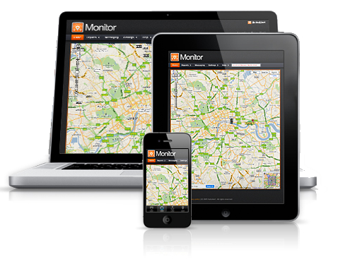
AutoAlert Tracker Application V2 is now live in the iTunes store.
Please note: This application has now been superseded by our AutoAlert Monitor application for iPhone and iPad.
Upgrade the application for free and get a host of new features including:
The application is also quicker and with improved look and feel to aide your tracking experience
Find out more about AutoAlert Monitor for iPhone and iPad

With new technology there any various different ways that you can track your vehicles. What technology you choose may vary somewhat depending on the size of the vehicle fleet. Large fleets tend to use equipment that is more elaborate because they can afford the greater cost, while small and medium-sized fleets generally use less expensive systems that offer less functionality. New technology, however, is rapidly changing the cost effectiveness and quality of tracking systems available to these small and medium-sized fleets.
Large fleets that can take advantage of economies of scale typically use some form of GPS tracking and a central base station or dispatch point. The vehicle units can be quite expensive, as can the base station infrastructure and staffing requirements. Only the largest fleets can usually afford the capital investment that is required and the long timeframe that is needed to gain a return on that investment. Additionally, these types of systems require a monthly fee that can quickly become quite expensive.
Most small and medium fleets will use some variation of vehicle tracking that is less costly to implement and support. For some this means using radios and a dispatch center, mobile telephones and a central office, or something similar. They may have a computer-based tracking process in the central location or, for very small fleets, they may opt instead for a simple map and manual tracking.
Quite a number of small fleets, in the range of one to ten vehicles, do not use active vehicle tracking at all. This may be due to the costs involved, lack of experience with tracking processes, or lack of awareness of the significant benefits that can be realized by an effective vehicle tracking system.
The newest technology available has the potential to radically alter the affordability and efficiency of vehicle tracking systems. Pioneered by AutoAlert, this system uses a small unit installed in the vehicle and a web-based interface that is accessed by a standard mobile telephone, laptop computer, or PC.
The advantages are many. First, the start-up cost of the system is extremely reasonable due to the relatively low cost of the vehicle unit itself. Second, there are no ongoing subscription or maintenance fees, thereby minimizing operating costs. And third, fleet managers can get access to tracking information from wherever they may be with just their mobile telephone. This allows them more freedom to get out of the office and into the field where their time is best used.
For the first time, small and medium-sized fleets can gain access to an economical and easy to use vehicle tracking system. This means they can start reaping the benefits of reduced driver downtime, more efficient dispatching, field replenishment of supplies, etc. In a competitive business model, the extra edge gained from efficient vehicle tracking can mean the difference between a fleet owner prospering or just getting by.
Find out more about AutoAlert GPS Tracking


 0207 099 5698